Offsetting Native Vegetation Loss on Private Land
Snapshot
Is the government achieving its biodiversity objective for permitted clearing on private land?
What we examined
We examined the Department of Environment, Land, Water and Planning (DELWP), 4 councils, and the Trust for Nature.
We looked at the way DELWP and the audited councils manage native vegetation clearing on private land.
Why this audit is important
Native vegetation forms the basis of Victoria's ecological communities and helps support the state's biodiversity.
The government has an objective of no net biodiversity loss for native vegetation on private land. This means any clearing should be permitted and offset, unless exempted.
What we concluded
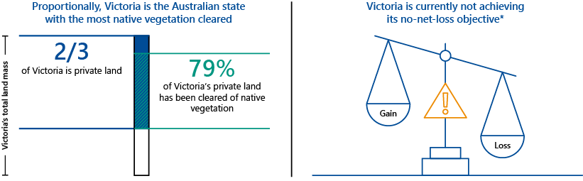
Victoria is not achieving its objective of no net biodiversity loss from native vegetation clearing on private land.
This is partly due to illegal clearing. DELWP acknowledges illegal clearing contributes significantly to the decline of native vegetation across the state and undermines investment in protecting the quality and cover of Victorian native vegetation.
Councils are primarily responsible for implementing regulations but do not effectively manage native vegetation clearing in their areas.
DELWP, which is responsible for setting policy and regulations, including reporting on the no net loss objective, has been slow to address known issues to support councils' implementation of the regulations.
What we recommended
We made 2 recommendations to the audited councils to improve their management of native vegetation.
We made 4 recommendations directly to DELWP to improve:
- its reporting on the no-net-loss objective
- the currency and completeness of its datasets and its management of the offset credit register
- its monitoring of clearing across the state, including using spatial imagery analysis
- its management of offset sites
- its support to councils in implementing the regulations.
We also made another recommendation for both DELWP and councils to confirm issues and determine strategies to effectively manage native vegetation clearing on private land.
Video presentation
Key facts
Note: *The no-net-loss objective refers to the objective for permitted clearing of native vegetation on private land in Victoria. This means permitted clearing has a neutral impact on Victoria’s biodiversity.
Source: VAGO.
What we found and recommend
We consulted with the audited agencies and considered their views when reaching our conclusions. Their full responses are in Appendix A.
Victoria is not achieving its no-net-loss objective
Victoria is not achieving its objective of no net biodiversity loss from native vegetation clearing on private land.
Reasons for this include:
- unauthorised clearings continue to take place across the state. The Department of Environment, Land, Water and Planning (DELWP) acknowledges that it is possible that substantial unauthorised removal is occurring with little or no enforcement. As these clearings do not go through the permit process, there are no offsets to compensate for their biodiversity loss
- while permitted clearing is offset, limitations in DELWP's assessment tools mean that in some parts of the state, DELWP cannot determine the required offset to fully compensate for biodiversity loss.
DELWP advised that other reasons for the loss of native vegetation on private land include exempted clearing and insufficient management of threats, such as weeds and pests.
DELWP estimates net loss for native vegetation on private land
HHa measures quality by scoring habitat attributes at a site in comparison to a reference point (benchmark) for the relevant vegetation type.
The result is expressed as a 'habitat score'.
HHa=extent x habitat score.
For example:
• 10 hectares with a habitat score of 100 per cent = 10 HHa
• 10 hectares with a habitat score of 50 per cent = 5 HHa.
DELWP's 2020 Net Gain Accounting Qualitative Update (the 2020 net gain report) estimates that every year, Victoria loses some 10,380 habitat hectares (HHa) of native vegetation on private land. We cannot verify the accuracy of this estimate, which is based on modelled data and a range of assumptions, because there is no actual data against which we can measure it. The report specifically notes that:
- the estimate is subject to ‘high variability and poorly quantified levels of uncertainty’
- ‘broad assumptions only are possible’ for losses arising from all types of clearing—permitted, exempted and illegal.
DELWP’s native vegetation reports do not report on outcomes
To date, the department has released 4 reports in accordance with its 2019 Monitoring, evaluation and reporting plan (the MER). However, none of these report on net biodiversity lost or gained from native vegetation clearing on private land. Instead of reporting on outcomes, the MER's evaluation measures focus on outputs and process.
The MER states that DELWP will report on whether the state is achieving its no net loss objective. However, the indicated evaluation questions to answer this are process measures instead of outcome measures.
The policy objective is quantitative—no net loss—and requires a quantitative performance indicator. DELWP's native vegetation reports do not include reporting on this outcome. DELWP acknowledges there is scope to improve its reports, including by reporting on the no-net-loss objective.
Data quality issues impact DELWP’s oversight
In this report we use ‘native vegetation calculator’ for ease of readability. We use it to refer to DELWP’s online assessment tool (underpinned by a native vegetation information management system and an environmental system modelling platform) that applicants and councils use to determine the amount and type of offset credit required to fully compensate for proposed clearings.
The offset credit register is DELWP’s database that records and manages offset sites and transactions to purchase offset credits.
We found data quality issues with DELWP's datasets for its offset credit register and native vegetation calculator. For example, DELWP does not have habitat distribution models (HDMs) for 477 threatened species—25 per cent of all threatened species in Victoria.
DELWP’s native vegetation calculator relies on HDMs to determine the nature and extent of biodiversity that will be affected by proposed clearings. This in turn determines the offset requirements that landowners must secure to fully compensate for the biodiversity loss. The lack of HDMs means that in parts of the state where the 477 threatened species reside, DELWP’s native vegetation calculator is unable to identify sufficient offset requirements. In these instances, the number of offset credits that landowners are required to purchase would not fully compensate for the loss of threatened species and their habitats.
We also found that DELWP's native vegetation reports on the number of council approved permits and established offset sites across the state are incomplete.
DELWP's processes and internal controls to manage the credit register do not prevent oversubscription of offset credits. There are also no quality assurance processes to ensure that recorded information is accurate.
DELWP's datasets and data management processes do not rate well against the Department of Premier and Cabinet's (DPC) Data Quality Guideline—Information Management Framework (data quality guideline). For example, DELWP’s datasets and processes rated poorly for the ‘accuracy’ and ‘completeness’ criteria. Our full assessment is in Appendix D.
Recommendations about native vegetation loss on private land
| We recommend that: | Response | |
|---|---|---|
| Department of Environment, Land, Water and Planning | 1. improve its native vegetation reporting by:
|
Accepted in principle |
2. develop and implement a data management protocol to ensure the currency and completeness of its native vegetation tools and datasets, including its assessment tools—the native vegetation information management system and the environmental systems modelling platform—and offset credit register, by:
|
Accepted |
Managing native vegetation clearing on private land
Councils are not adequately managing native vegetation clearing on private land and have not taken effective action against unauthorised clearing.
DELWP is aware of the key reasons for councils' failures to implement regulations but has been slow to address the issues to support councils' implementation of the regulations.
Councils are not consistently applying the mitigation hierarchy
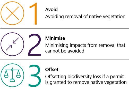
The regulations' mitigation hierarchy requires councils—when processing planning permits for native vegetation removal—to approve removal only as a last resort. That is, they must first confirm that removal is unavoidable and cannot be further minimised.
When councils fail to apply the mitigation hierarchy, clearing and offsetting becomes the default position. This means the state could incur unnecessary biodiversity loss. Only Nillumbik Shire Council (Nillumbik) and Yarra Ranges Shire Council (Yarra Ranges) have effective controls to ensure they comply with the mitigation hierarchy.
Councils have limited knowledge of the number of permits they issue
None of the 4 audited councils can reliably say how many permits with native vegetation requirements they issued from July 2018 to June 2020. Audited councils explained that determining actual numbers requires a manual process that would take a significant amount of time to complete.
DELWP acknowledges that the permit data it includes in its annual reports is neither current nor complete. It explained that while it refers to various sources, ultimately it relies on councils to report on their permit data. However, we found that DELWP can use its own native vegetation calculator to obtain permit data. This is because DELWP's calculator stores information on all permit applications approved by councils. DELWP advised that its tools are not currently configured to readily identify approved permits. However, it could add functionality to enable this differentiation and directly obtain permit data.
DELWP is now considering options to better track permit data using its Planning Permit Activity Reporting System (PPARS) and the native vegetation calculator.
We explored different tools to help compare the extent of clearing across the state and found that spatial imagery analysis can help in this exercise.
Councils are not ensuring clearing is either permitted or exempt
Ensuring clearings are either permitted or exempt
Despite being responsible for private land clearing under the regulations, councils cannot demonstrate that all clearing in their areas was permitted or done under an exemption. All audited agencies acknowledged that unauthorised clearing takes place across the state.
Audited councils told us that unless they receive community complaints on illegal clearing or permit holders consult them about their plans to undertake exempted clearing, they have no knowledge or visibility of this clearing.
Taking action against unauthorised clearing
The audited councils have not been able to prevent and take effective action against illegal clearing. DELWP documentation reveals that this is true of councils across the state.
DELWP documentation from 2019 reveals that the department is aware of the key reasons councils have not taken effective action against unauthorised clearings. These include:
- lack of council staff resourcing
- budget constraints
- insufficient staff knowledge and capability to implement the regulations
- history of poor outcomes from enforcement actions, where court-imposed fines are considerably less than the cost of offset credits.
DELWP's Illegal Clearing Working Group
In August 2019, DELWP established the Illegal Clearing Working Group (ICWG) and tasked it to develop an action plan to:
- deliver more effective administration of Victoria's native vegetation regulations
- reduce the impacts of unauthorised vegetation removal.
In June 2020, due to resourcing constraints and work prioritisation, DELWP reduced the plan's action items from 43 to 20. In streamlining the actions, DELWP advised that it used criteria developed by its economics unit. Previously identified actions to revise the legislative framework and improve DELWP’s statewide scanning and reporting were not among the remaining 20 action items.
The group's latest March 2021 update report shows that it has made some progress, such as hosting the Native Vegetation Compliance Community of Practice to improve councils' capabilities. However, overall progress has been slow and DELWP has not committed to a date for completion of the revised action plan.
Councils are not effectively monitoring and enforcing compliance
Compliance with permit conditions—securing offsets before removal
First-party offset sites are on land owned by the holder of a permit to remove native vegetation. They are used to meet landowners’ own offset requirements.
Third-party offset sites are on land owned by another party. They are established under section 69 of the Conservation, Forests and Lands Act 1987. Permit holders can buy native vegetation credits from other landowners to meet their offset requirements.
It is a condition of permits that before clearing native vegetation, a landowner must secure offset credits through establishing a first-party offset site or from third-party offset sites.
Nillumbik and Yarra Ranges have processes in place requiring landowners to present proof of purchased offsets before allowing the removal of native vegetation. Baw Baw Shire Council (Baw Baw) and Campaspe Shire Council (Campaspe) do not have similar processes. Campaspe has an audit program to check whether permit holders secure offsets within 2 years of getting the permit. However, this process does not inform the council if the purchase of offsets occurred before clearing.
Compliance with permit conditions—clearing consistent with permit
In most cases, councils do not ensure that the vegetation removed is consistent with the permit. Except Nillumbik, all other audited councils do not know whether landowners remove only what their permits allow because they do not have resources to monitor clearing.
Nillumbik told us that where a planning permit for native vegetation removal is issued together with a building and works permit, it can monitor and ensure that clearing is consistent with what the permit allows. This is because there are often pre site checks required as part of the permit conditions
DELWP is not consistently monitoring third-party offset sites
DELWP actively monitors offset sites in the first 10 years of their establishment.
DELWP acknowledges that ongoing maintenance, beyond the first 10 years, is key to protecting biodiversity gains from threats, such as pests and weeds. DELWP advised that it has begun monitoring sites after the first 10 years of their establishment. However, we found that DELWP’s communications with offset site owners on the new reporting and monitoring requirements have not been consistent.
DELWP also does not have a consistent management plan to ensure regular maintenance works for 16 of the 17 sites it manages on Crown land, which is land owned by the state or Australian government.
Recommendations about managing native vegetation clearing
| We recommend that: | Response | |
|---|---|---|
| Department of Environment, Land, Water and Planning | 3. improve its oversight and monitoring of the extent of native vegetation clearing across the state by:
|
Accepted in principle |
4. review and improve its management of offset sites by:
|
Accepted | |
| Department of Environment, Land, Water and Planning, Baw Baw Shire Council, Campaspe Shire Council, Nillumbik Shire Council and Yarra Ranges Shire Council | 5. work together and consult with other councils and stakeholders to:
|
Accepted by: Campaspe Shire Council, Nillumbik Shire Council Accepted in principle by: DELWP Partially accepted by: Baw Baw Shire Council, Yarra Ranges Shire Council |
| Campaspe Shire Council and Baw Baw Shire Council | 6. develop controls and processes to effectively and consistently apply the mitigation hierarchy when processing permit applications, including by independently verifying that the proposed clearing is unavoidable or cannot be minimised (see Section 3.2) | Accepted by: Campaspe Shire Council Partially accepted by: Baw Baw Shire Council |
| Baw Baw Shire Council, Campaspe Shire Council, Nillumbik Shire Council and Yarra Ranges Shire Council | 7. develop and implement controls and processes to:
|
Accepted by: Campaspe Shire Council, Nillumbik Shire Council Partially accepted by: Baw Baw Shire Council, Yarra Ranges Shire Council |
1. Audit context
Native vegetation is a fundamental feature of our natural heritage. Its removal is the primary cause of biodiversity loss.
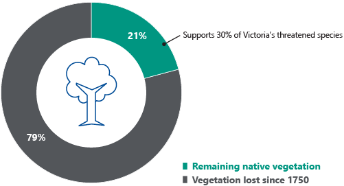
DELWP estimates 54 per cent of Victoria's original native vegetation has been cleared since European settlement. On private land, only 21 per cent of the state’s original native vegetation cover remains. Proportionally, this makes Victoria the Australian state with the most native vegetation cleared.
Native vegetation removal is a regulated activity in Victoria. DELWP is responsible for setting the policy and regulations, including reporting on the state's no-net-loss objective. Councils are primarily responsible for implementing the regulations.
This chapter provides essential background information about:
1.1 Victoria's native vegetation
Victoria's many indigenous plant species—native vegetation—are critical to the state's biodiversity. These trees and shrubs, herbs, grasses and other plants provide a range of habitats, from alpine areas and tall forests to fertile plains, wetlands and deserts.
Diverse flora and fauna species rely on native vegetation. Since European settlement in Victoria, removal of native vegetation has contributed to the extinction of 61 animal and plant species and the classification of a further 1,904 species as rare or threatened.
Native vegetation plays other important roles, including contributing to climate change adaptation and mitigation, agricultural and economic activities and human wellbeing. The key benefits of intact native vegetation include:
- maintaining and improving land productivity, including by controlling erosion and salinity
- maintaining and improving water quality and waterways
- providing food and raw materials
- providing places for Aboriginal and Torres Strait Islander communities' cultural practices
- promoting a sense of place and wellbeing for all Victorians.
Removing native vegetation not only further reduces what is left of it, but also affects its condition and quality.
Much of Victoria's native vegetation on public land, especially within national parks and reserves, is in good condition with high species diversity. In contrast, native vegetation on private land is generally in fragmented parcels of lower quality and faces ongoing decline from land-use activities, weeds and pest animals.
Native vegetation loss in Victoria
Proportionally, Victoria is the most settled and cleared state in Australia, with significant conversion of native habitats for agriculture and urbanisation, including residential and commercial developments.
Documents from DELWP show that some 54 per cent of the state's original native vegetation has been cleared since European settlement. Breaking this down, since 1750, Victoria has lost 79 per cent of native vegetation on private land, compared with 12 per cent on public land.
Private land covers two-thirds of the Victorian landscape and provides habitats for some of the state’s most threatened species along with important and irreplaceable native vegetation. Figure 1A shows that although only 21 per cent of native vegetation remains on private land, it supports 30 per cent of Victoria’s threatened species populations.
Figure 1A: Remaining native vegetation on private land in Victoria
Source: VAGO, based on DELWP documentation.
HHa is a site-based metric for assessing the extent and quality of native vegetation.
In 2008, the then Department of Sustainability and Environment estimated that Victoria was losing native vegetation on private land at the rate of 9,900 HHa per year. Figure 1B shows that although removing native vegetation is a regulated activity in Victoria, the state continues to lose native vegetation cover on private land.
FIGURE 1B: Annual changes in native vegetation on private land and public land
Source: VAGO, from DELWP's 2020 net gain report.
Scoring biodiversity losses and gains
Gain is the predicted improvement in biodiversity value of native vegetation at a site due to active management and increased security of the native vegetation. For an offset site to deliver a gain, it must be secured in perpetuity and managed to maintain and improve the condition of native vegetation.
Loss refers to the loss in biodiversity when native vegetation is fully or partially removed.
Both gain and loss are measured by biodiversity scores or units.
DELWP assesses changes in biodiversity in terms of losses and gains. Under the native vegetation regulations, both gain and loss are measured by habitat units.
|
When a native vegetation site is … |
then the biodiversity value … |
|---|---|
|
predicted to improve due to:
|
is scored as a gain and can be used as an offset, provided it will be:
|
|
fully or partially removed (cleared) |
is scored as a loss. |
1.2 Managing native vegetation loss
Regulatory framework
Management of native vegetation in Victoria operates under the state's planning system, which is governed by the Planning and Environment Act 1987 (P&E Act) and subordinate legislation, the Victoria Planning Provisions (VPP).
DELWP is the responsible department and has developed the following resources:
- DELWP's 2017 Guidelines for the removal, destruction or lopping of native vegetation (DELWP's removal guidelines) underpin the VPP's native vegetation clauses. This document is incorporated in the state's planning system
- Victoria's native vegetation removal regulations (the regulations) include DELWP's removal guidelines and relevant sections of the P&E Act and the VPP. DELWP has developed a number of tools and documents to support the application of these regulations.
No-net-loss objective and the mitigation hierarchy
In 2014, the government revised its policy objective for native vegetation clearing on private land from 'net gain' to 'no net loss'.
Clause 12 of the VPP states that the overall objective of native vegetation management is 'to ensure that there is no net loss to biodiversity as a result of the removal, destruction or lopping of native vegetation’. According to DELWP's removal guidelines, the state will achieve this policy objective through a mitigation hierarchy. This is shown in Figure 1C.
Under the mitigation hierarchy, councils must approve native vegetation removal only in instances where the removal cannot be avoided or minimised.
FIGURE 1C: Three-stage mitigation hierarchy to achieve no-net-loss objective
Source: VAGO, based on the regulations.
How offsets work
DELWP's removal regulations require Victorians who need to remove native vegetation to compensate for the biodiversity loss from 'unavoidable' native vegetation removal through offset credits. These can be either on the same piece of land or from a third-party offset site. Figure 1D shows an example of this.
FIGURE 1D: Case study 1
A landowner wishing to remove 5 eucalyptus trees from their property.
In this example, the landowner must first apply for a native vegetation permit from their local council.
To process the application, the council will apply the mitigation hierarchy, assessing whether the proposal is unavoidable or able to be minimised. If the council considers that all or part of the proposed removal cannot be avoided, it will determine the:
- biodiversity loss from the proposed clearing
- corresponding offset credits to neutralise or compensate for such loss.
The landowner must then secure the required offset credits, either on their own property or from a third-party offset site.
Source: VAGO
Securing offset credits
A permit holder can secure offsets in one of 2 ways:
|
A permit holder can ... |
by ... |
|---|---|
|
set up a new offset site on their own land (first-party offset) |
establishing a first-party offset agreement |
|
purchase native vegetation credits from a third-party offset site |
searching the Native Vegetation Credit Register (a statewide register administered by DELWP) and contacting a third-party offset provider to negotiate the purchase of credits. |
Protecting offset sites
According to DELWP's records, there are 386 offset sites across the state:
- 3 first-party sites
- 17 owned by the Crown and managed by DELWP
- 366 third-party sites.
The offset sites cover over 19,000 hectares and, when established, offered a total of 5,287 offset credits for sale.
All offset site landowners are required to permanently protect their sites with one of the following on-title security agreements:
- a section 69 agreement under the Conservation Forest and Lands Act 1987 with DELWP
- an offset covenant under section 3A of the Victorian Conservation Trust Act 1972 with Trust for Nature (TfN)
- a section 173 agreement under the P&E Act with the council.
Under section 9 of DELWP's removal guidelines, Victorians can also establish an offset by transferring freehold land to the Crown. The Crown land manager maintains these sites under a memorandum of understanding with DELWP's secretary.
Exempted clearing
The VPP do allow for exemptions—instances where a landowner is not required to obtain a permit to clear native vegetation. Reasons include clearing required for fire protection, personal use, grazing or fencing. In most of these cases, the person who wishes to clear native vegetation does not need to offset the biodiversity loss.
DELWP's Protecting Victoria's Environment—Biodiversity 2037 provides that government will 'counterbalance' biodiversity loss from exempted native vegetation clearing at 'a whole-of-state level through investment, management or other means'. This is to ensure that 'all biodiversity losses are accounted for and consistently addressed'.
Unauthorised (or illegal) clearing
Unauthorised clearing occurs when a landowner removes native vegetation:
- without a native vegetation permit and without being exempted under the regulations
- with a permit in place, but clears beyond the permit conditions. For example, the landowner is permitted to remove a hectare of grassland only but instead removes 2 hectares and several native trees
- as an exempted clearing, but goes beyond allowable limits. For example, the landowner cuts some branches of their native trees for personal use but cuts more to sell to their neighbours.
Figure 1E summarises the relationship between permitted clearing, illegal clearing and exempted clearing of native vegetation.
Figure 1E: Types of native vegetation clearing
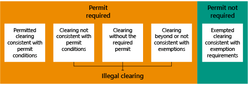
Source: VAGO, based on the regulations
1.3 Regulatory requirements, roles and responsibilities
Legislation and regulations
There is a range of legislation and a number of regulations involved in managing native vegetation clearing in Victoria. These are summarised in Figure 1F.
FIGURE 1F: Summary of regulations for managing native vegetation
| Relevant regulations | Purpose |
|---|---|
| P&E Act | Provides a framework for the state's planning, including native vegetation management |
| VPP | Subordinate legislation of the P&E Act |
| Clause 12 of the VPP | Sets no-net-loss objective for native vegetation management |
| Clauses 52.12 and 52.17 of the VPP | Require applicants to obtain a permit and secure an offset to compensate for biodiversity loss |
| DELWP's removal guidelines | DELWP's native vegetation policy document |
| A section 69 agreement under the Conservation Forest and Lands Act 1987 with DELWP An offset covenant under section 3A of the Victorian Conservation Trust Act 1972 with TfN A section 173 agreement under the P&E Act with local government |
Agreements to protect offset sites |
Source: VAGO
Roles and responsibilities
DELWP, local government and other responsible authorities, such as TfN, all have a role in implementing and ensuring compliance with the native vegetation removal and offset regulatory framework. Figure 1G outlines these roles and responsibilities.
FIGURE 1G: Roles and responsibilities
| Responsible authorities | Responsibilities |
|---|---|
|
DELWP
|
|
| Local government entities (councils) |
|
| TfN |
|
Source: VAGO
2. Native vegetation loss
Conclusion
The government is not achieving its no-net-loss biodiversity objective for native vegetation on private land. DELWP acknowledges that this is in part due to substantial unauthorised clearing occurring across the state, which evades offset requirements. This means that the state continues to lose critical native vegetation cover that supports our threatened species.
DELWP estimates that Victoria loses some 10,380 HHa of native vegetation on private land every year. DELWP's figures are based on modelled data and a range of assumptions. We cannot verify this estimate because there is no actual data against which we can measure it.
This chapter discusses:
2.1 Loss of native vegetation on Victorian private land
DELWP's regulations rely on offset credits fully compensating for biodiversity loss due to clearing of native vegetation. This in turn relies on private landowners securing permits, which is the process that triggers offset credits.
The state cannot achieve its no-net-loss objective if:
- there are unauthorised clearings, as these are not compensated by offset arrangements
- DELWP's native vegetation calculator is unable to appropriately determine the required offset credits for proposed clearings (that go through the permit process).
The government is not achieving its no-net-loss policy objective
The government is not achieving its no-net-loss biodiversity objective for native vegetation on private land. This is in part due to unauthorised clearing that takes place across the state and the inability of DELWP's native vegetation calculator to accurately determine the required offset in some parts of the state.
DELWP advised that other reasons for the loss of native vegetation on private land include exempted clearing and insufficient management of threats, such as weeds and pests.
Unauthorised native vegetation clearing
DELWP acknowledges that substantial unauthorised removal of native vegetation is occurring across Victorian local government areas. Unless this issue is addressed, it is unlikely that the government will achieve its no-net-loss objective.
We discuss unauthorised clearing further in Section 3.2.
DELWP's native vegetation calculator
DELWP does not have HDMs for 477 threatened species. DELWP’s native vegetation calculator relies on HDMs to determine the nature and extent of biodiversity that will be affected by proposed clearings. This in turn determines the offset requirements that are included in permit conditions. But in the absence of HDMs for 477 threatened species, permits granted to clear parts of the state where these species reside will not appropriately require the offsets that would fully compensate for the loss of threatened species.
DELWP advised that many of these species would generally be co-located with other threatened species that have a HDM. However, DELWP’s native vegetation calculator currently does not reflect this co-location to require appropriate offsets that cover unrepresented threatened species.
Moreover, DELWP told us that it does not currently have sufficient information to complete HDMs for these species and that difficulties in obtaining relevant information may mean that there will always be gaps in its tools and datasets. This is a serious issue because the state’s remaining 21 per cent native vegetation cover supports 30 per cent of our threatened species (as shown in Figure 1A). It is important that the 477 threatened species that do not have HDMs are represented in DELWP’s native vegetation calculator so that the appropriate offsets are required from landowners.
DELWP also advised that any interested party can inform their local council about the presence of a threatened species or habitat and DELWP can then consider this when determining required offsets. However, this relies on a community being aware of a landowner’s intention to remove native vegetation because the permit process does not always require public notification.
2.2 DELWP's native vegetation reporting
DELWP's regulatory, strategy and design (RS&D) unit has oversight of and responsibility for the state’s framework for offsetting native vegetation removal.
Since DELWP revised its native vegetation removal guidelines in 2017, the RS&D unit has published 3 annual reports and one 3-yearly report. This frequency is in accordance with the MER.
In 2008 and 2022, another part of DELWP, the biodiversity strategy and knowledge unit, published reports estimating the native vegetation net gain/loss across the state's public and private land.
DELWP estimates net loss for native vegetation on private land
In its 2020 net gain report (published in 2022), DELWP estimates that Victoria loses some 10,380 HHa of native vegetation from private land every year.
Figure 2A shows DELWP's net loss estimates for private land since 2008.
FIGURE 2A: Estimated net loss: Victoria's native vegetation on private land
| 2008 (HHa/year) |
2015 (HHa/year) |
2020 (HHa/year) |
|
|---|---|---|---|
| Gain (subtotal) | +4,560 | +3,100 | +3,090 |
| Loss (subtotal) | −14,550 | −13,400 | −13,470 |
| Net outcome (total loss) | −9,990 | −10,300 | −10,380 |
Note: Gain components include offsets for permitted clearing, unallocated native vegetation credits; government programs such as weed management partnerships and permanent protections. Loss components include permitted clearing, entitled uses, exemptions, insufficient management of threats, and losses detected from satellite imagery.
*The 2015 report was not published.
Source: VAGO, based on information from DELWP's biodiversity strategy and knowledge unit.
We cannot verify the accuracy of DELWP’s estimates. This is because there is no available data against which we can measure the actual net biodiversity loss or gain from native vegetation clearing on private land.
In its 2020 net gain report, DELWP notes that its calculation is based on 'once-off modelled native vegetation extent and condition, and a range of assumptions regarding specific transactions and broad changes'. The report specifically notes that:
- the estimate is subject to ‘high variability and poorly quantified levels of uncertainty’
- broad assumptions only are possible’ for losses arising from all types of clearing—permitted, exempted and illegal.
The 2020 net gain report considered estimates of losses from exempted and illegal clearings on private land. It also considered estimates of gains from unallocated native vegetation credits, government programs, such as weed management partnerships and permanent land protection arrangements for private land.
Figure 2B illustrates the types of unauthorised clearing that requires council-issued permits.
FIGURE 2B: Unauthorised native vegetation removals
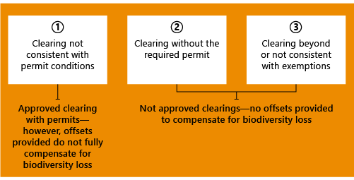
Source: VAGO, based on DELWP documentation.
DELWP’s native vegetation reports to date do not report on outcomes
DELWP advised that its RS&D unit’s reports include assessments on progress against the state’s no-net-loss biodiversity objective. According to our assessment this is not accurate. None of the 4 documents published by the unit (as required by DELWP’s MER) reported on the extent of net biodiversity lost or gained from clearing native vegetation on private land. Instead of reporting on outcomes, DELWP's MER evaluation focuses on outputs and process measures.
The MER said that DELWP will report on whether the state is achieving its no-net-loss objective. However, the indicated evaluation questions for this are the following process measures rather than outcome measures:
- whether decisions on native vegetation removal are made in accordance with the removal guidelines
- whether offset sites comply with management actions.
The state's policy objective is quantitative in nature—no net loss—and requires a quantitative performance indicator.
In its MER:
|
DELWP states that it will report on … |
but these are … |
meaning that … |
|---|---|---|
|
'permit numbers, extent of native vegetation approved to be removed, extent of native vegetation protected at offset sites' |
output, not outcome, measures |
while DELWP is capturing some useful information relative to output measures, it cannot demonstrate progress against the objective. |
|
'whether the systems and tools that support the regulations are allowing the regulations to be applied in an efficient and effective way' |
process, not outcome, measures |
while DELWP can use this information to ensure it uses tools efficiently and identifies offsets, it cannot demonstrate that offsets fully compensate for cleared native vegetation. |
|
'how well the regulatory system is working’ |
DELWP acknowledges there is scope to improve its reports to include reporting on the no-net-loss objective and that this will be reflected in its future reports.
2.3 Quality issues with DELWP’s data
DPC's data quality guideline gives Victorian Government departments a benchmark against which they can assess, maintain and improve the quality of their critical and shared datasets.
The datasets underpinning DELWP's native vegetation calculator and offset credit register do not fully comply with DPC's data quality guideline. Appendix D details our compliance assessment.
Data quality issues impact DELWP’s oversight
DELWP’s data quality issues affect the reliability of its native vegetation reports. For example, DELWP’s reports on the number of council-approved permits (see Figure 3A) and established offset sites are incomplete. DELWP acknowledges that only a handful of first-party offset sites are included in its reports because it does not have information on most first-party offset sites across the state.
DELWP acknowledges that there are data quality issues with its reported information and is working to improve the way it collects data. For example, DELWP is exploring options for using its native vegetation calculator and PPARS to obtain accurate permit data directly.
Discrepancies in DELWP’s native vegetation credit register
DELWP uses its native vegetation credit register to record data on offset sites and manage offset credit trading transactions. However, its processes for managing the register lack sufficient controls.
Our review of register data revealed confusing and variable entries on what should be consistent values for the:
- number of offset sites established across the state
- land area (hectares) of offset sites
- number of offset credits from offset sites available for trading.
DELWP was only able to explain the reasons for half of the discrepancies we identified.
DELWP does not have process controls to minimise risks, including errors in recorded information as well as oversubscription of offset credits. For example:
|
We observed … |
meaning … |
which matters because … |
|---|---|---|
|
that only 2 staff members have access to the credit register and both staff have full access to record and revise data |
there is insufficient separation of duties |
there are no checks and balances for changes, even when done inadvertently, which impacts data accuracy and integrity. |
|
there is insufficient staff for backup |
the credit register could be out of action for an extended period if both staff members are away or otherwise unavailable. | |
|
that no recorded data is stored in locked mode |
all data can be revised or deleted at any time without authorisation or explanation |
systems controls, such as requiring approval and recording the rationale for changes, are critical in assuring data is not corrupted. |
|
5 instances where offset credits were oversubscribed |
credits may be traded more than once without being detected in the register |
some native vegetation removals are not being actually offset as required, which directly impacts achievement of the no-net-loss objective. |
DELWP advised that oversubscription (overtrading) is a legacy system issue and that it has increased its controls to prevent this from happening—specifically, that it has added an alert message function to its credit register.
However, our examination reveals that oversubscription remains a key risk to the integrity of the system. This is because there are no controls to prevent staff from changing data on offset credits, either intentionally or inadvertently.
For example, during our assessment of the credit register, we found that it is possible for staff to save any changes without prompting a review or recording an explanation for the change. Data changes can include changes on the number of purchased credits or available credits for purchase, which could lead to oversubscription. This highlights control weaknesses in the credit register.
3. Managing native vegetation clearing
Conclusion
Councils are not adequately managing native vegetation clearing on private land and cannot take effective action against unauthorised clearing.
DELWP, which is responsible for setting the native vegetation management policy and regulations, is aware of key reasons for councils' failure to implement regulations but has been slow to act to address issues to support councils' effective implementation of the regulation.
This chapter discusses:
3.1 Native vegetation permit assessment
Councils are responsible for assessing and approving planning permits for native vegetation removal.
Councils not consistently applying the mitigation hierarchy
Under the mitigation hierarchy, councils should approve removal of native vegetation only as a last resort. They must first be clear that it is unavoidable and is always minimised.
If councils do not apply the mitigation hierarchy, offsetting becomes the default position. This can lead to unnecessary biodiversity loss for the state. However, not all audited councils consistently assess applications to verify that the 'avoid' and 'minimise' options have been fully considered:
| While … | the … |
|---|---|
| Nillumbik’s and Yarra Ranges’ assessment reports specify the actions they took to confirm that an offset arrangement is the only viable option | Baw Baw and Campaspe only record their assessment in some but not all applications (based on a selection of permit documentation we examined). |
Councils have limited knowledge of the number of permits they issue
None of the 4 audited councils can reliably say how many permits with native vegetation requirements they issued between July 2018 and June 2020.
Baw Baw acknowledged that the list it provided us ‘is incorrect’ and that ‘the actual number is significantly higher’. It also advised that the discrepancies often arose where native vegetation removal is one requirement as a part of a larger planning permit—the information system does not allow easy identification of this type of permit.
Nillumbik on the other hand maintains that while it could account for all its permits, it would take a significant amount of time to undertake the manual process of going over voluminous hard-copy files and checking permits one by one.
DELWP has been requesting this information from councils since 2018. However, the audited councils told us the annual data they provide was not accurate.
The councils explained that their reports to DELWP are largely based on the count generated by their information management systems (IMSs). These only identify permits when the title included the phrase ‘native vegetation clearing’. Councils advised that they are revising their IMSs to better reflect permit data.
Figure 3A compares the permit data that audited councils gave us in November 2021 with figures from DELWP's Annual Report 2019–20—A report on the operations of the native vegetation removal regulations.
FIGURE 3A: Differences between councils’ and DELWP’s records of approved permits for native vegetation clearing between July 2018 and June 2020
| Number of approved permits for native vegetation clearing | |||
|---|---|---|---|
| Council | Recorded by council | Reported by DELWP | Difference |
| Baw Baw | 9 | 5 | 4 |
| Campaspe | 22 | 19 | 3 |
| Nillumbik | 162 | 99 | 53 |
| Yarra Ranges | 122 | 72 | 50 |
| Total | 305 | 195 | 110 |
Note: *Campaspe advised that 'there was an error in the 2018–19 report that went to the department that had the permit numbers of 3 permits incorrectly numbered'.
Source: VAGO, based on councils’ data and DELWP’s Annual Report 2019–20—A report on the operations of the native vegetation removal regulations.
DELWP's limited permit data
DELWP is responsible for reporting on the government's no-net-loss biodiversity objective and has oversight of the regulations in general, so it is important that it has accurate native vegetation permit data.
DELWP acknowledges that its permit data is neither current nor complete. It explained that while it refers to a range of data, including its Statutory Planning Case Management System and PPARS, it ultimately relies on councils to report their permit data.
Rather than relying on councils, we found that DELWP could use its own native vegetation calculator to obtain data on the number of permits approved by councils. Although DELWP advised that its calculator is not currently configured to readily identify approved permits, it could add functionality to enable this differentiation to directly obtain permit data.
Spatial imagery analysis looks at locations, attributes and relationships of features in spatial data through overlay and other analytical techniques.
DELWP is now considering options to better track the actual number of approved permits using PPARS and its native vegetation calculator.
Spatial imagery analysis reveals more clearings
We explored different tools to help compare the extent of clearing across the state and found that spatial imagery analysis can be helpful in this exercise. Figure 3B shows an example of this.
FIGURE 3B: Case study: vegetation clearing in Baw Baw
Our spatial imagery analysis shows that potentially more clearing has occurred than is recorded in DELWP’s data for permitted clearing.
DELWP reported that Baw Baw approved 5 permits with native vegetation requirements in the period from July 2018 to June 2020. In contrast, the council reported 9. Our analysis of spatial imagery shows that there were more than 100 instances of vegetation clearing across Baw Baw in the same period.
The orange shapes show where vegetation was cleared. There are significantly more orange shapes than the 5 permits issued by the council from July 2018 to June 2020.
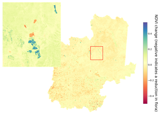
Note: NDVI stands for normalised difference vegetation index. This index describes the difference between visible and potentially cleared vegetation over time. A negative index number indicates high vegetation removal.
Source: VAGO, based on information from DELWP and Baw Baw.
There are limitations to publicly available spatial data, including the difficulty of identifying whether clearing:
- involved native or non-native vegetation
- was permitted, exempted or unauthorised.
Also, councils need dedicated resources and training to effectively use this tool. However, our analysis shows that spatial imagery tools can be used as part of a suite of tools and controls to identify clearing at a council and state level.
3.2 Monitoring and enforcing compliance
According to the regulations, and as indicated in DELWP’s 2017 Compliance and Enforcement Strategy—Native vegetation removal regulations, councils have the primary responsibility to:
- ensure native vegetation cleared is either permitted or exempt
- monitor landowners’ compliance with requirements for first-party offset sites
- monitor landowners’ compliance with native vegetation permit conditions.
Councils are not ensuring clearing is either permitted or exempt
There is nothing in councils' current processes that allows them to proactively identify illegal clearing. Unless councils address this gap, they will not be able to meet their responsibility under the regulations to ensure that only permitted and exempted clearing takes place in their localities.
This is because contrary to their responsibility under the regulations, councils cannot ensure that all native vegetation clearing in their localities is either permitted or exempted. All audited agencies acknowledge that unauthorised clearing takes place across the state.
Audited councils told us that, unless they receive community complaints about illegal clearing, or permit holders consult them about their plans to undertake exempted clearing, they have no knowledge or visibility of these clearings.
Unauthorised clearing
The regulations require councils to take enforcement action against illegal clearing. However, audited councils have not been able to do this effectively. DELWP documentation reveals that this holds for councils across the state.
For example, from July 2018 to June 2021 Baw Baw received community complaints about 69 instances of alleged illegal clearing. However, the council took action in only 5 instances. It advised that it has insufficient resources to address unauthorised clearing and that the costs to pursue enforcement often exceed the sums recovered in fines.
DELWP's documentation from 2019 reveals that the department is aware of the key reasons for councils' failure to take action against unauthorised clearings. These include:
- lack of council staff resourcing
- budget constraints
- lack of staff knowledge and capability to implement the regulations
- a history of poor outcomes from enforcement actions where court-imposed fines are considerably less than the cost of offset credits.
DELWP's ICWG
In August 2019, DELWP established the ICWG and tasked it to develop an action plan to:
- deliver more effective administration of Victoria's native vegetation regulations
- reduce the impacts of unauthorised vegetation removal.
The plan identified 43 actions to achieve its objectives. The actions highlight education, council capability and capacity, improvements in DELWP's statewide scanning and reporting, and revisions in the legislative framework.
However, in June 2020, due to resourcing constraints and work prioritisation, DELWP re-scoped the focus of the action plan and reduced the actions from 43 to 20. In streamlining the actions, DELWP advised that it determined the final list of actions using criteria developed by its economics unit. Previously identified actions to revise the legislative framework and improve DELWP’s statewide scanning and reporting did not make the prioritised 20 action item list.
DELWP's March 2021 progress update shows that the ICWG has hosted a Native Vegetation Compliance Community of Practice to help boost councils' capabilities. However, DELWP has not committed to a timeline on when the working group will complete its action plan.
Councils are not effectively monitoring and enforcing compliance
Councils have not consistently complied with their responsibilities to ensure permit holders meet permit conditions and monitor first-party offset sites.
Compliance with permit conditions
Allocated credit extract is the permit holder's proof of purchase of offset credits. DELWP issues this extract once it records the offset transaction in the credit register
It is a condition of permits that before clearing native vegetation, a landowner must first secure offset credits through third-party offset sites or establish their own (first party) offset sites. To prove they have done this, a landowner must show the council either an allocated credit extract (ACE) or, in rare cases, a first-party offset site agreement.
However, as shown in Figure 3C, for the 2-year period from July 2018 to June 2020, only 50 per cent of permits could be matched to an ACE.
Nillumbik and Yarra Ranges councils introduced processes in 2019 requiring landowners to present an ACE before removing native vegetation. On the other hand, Baw Baw and Campaspe do not have similar processes. Campaspe does have an audit program that enables it to check whether an ACE was secured within 2 years of the council issuing the permit though.
FIGURE 3C: Comparing numbers of permits issued against ACEs
| Council | Number of permits issued | Number of ACEs received | Ratio of ACEs to permits (%) |
|---|---|---|---|
| Baw Baw | 5 | 5 | 100 |
| Campaspe | 19 | 7 | 36.8 |
| Nillumbik | 99 | 46 | 46.45 |
| Yarra Ranges | 72 | 54.2 | |
| Total | 195 | 97 | 49.7 |
Note: *Figure 3A shows that councils recorded more permits than they reported to DELWP, which means the number of missing ACEs could potentially be more than reported here. Numbers reported are for the period July 2018 to June 2020.
Clearings relative to some permits may not have commenced at the time of reporting, therefore these may not have corresponding ACEs. Some ACEs reported may refer to permits issued in previous years.
Source: VAGO, based on DELWP’s Annual Report 2019–20—A report on the operations of the native vegetation removal regulations.
While it is possible that some permit holders do not proceed with the removal of native vegetation, DELWP does not have information on this or on how many permits have expired or been withdrawn and therefore do not require ACEs.
Compliance with permit conditions—clearing consistent with a permit
In general, audited councils do not know whether applicants only clear what is permitted.
However, Nillumbik advised that, in instances when a planning permit for native vegetation removal is issued together with a building and works permit, it can monitor and ensure that vegetation clearing is consistent with what the permit allows. This is because there are often pre-site checks required as part of the permit conditions.
Monitoring first-party offset sites
All audited councils advised that other than acting on community complaints, they do not monitor landowners’ compliance with their first-party offset sites' obligations.
They explained that this is because they do not have sufficient resources to prioritise native vegetation compliance over other urgent needs, such as bushfire preparation.
DELWP is not consistently monitoring third-party offset sites
DELWP monitors third-party offset sites within the first 10 years of their establishment.
DELWP has established processes to ensure that offset site owners comply with their obligations under their third-party offset sites agreements. This includes maintaining the site and submitting annual compliance reports to DELWP during the first 10 years of the agreement.
Third-party offset sites—beyond 10 years
DELWP acknowledges that ongoing maintenance is key to protecting biodiversity gains from these sites and it has begun monitoring sites after the first 10 years of their establishment.
DELWP’s process is to:
- monitor the sites' condition once every 5 to 10 years
- require site owners to report on their maintenance works in years 13, 17, 25 and every 10 years thereafter.
However, we found that DELWP’s communications with site owners on these new requirements have not been consistent. DELWP advised that it has started to address this issue.
TfN has an established approach to manage offset sites beyond 10 years, as Figure 3D shows.
FIGURE 3D: Case study: TfN’s approach in managing offset sites
TfN is responsible for offset sites secured with a TfN covenant.
Unlike DELWP, TfN has an established process to monitor offset sites beyond 10 years.
At the end of the 10-year active management period, TfN enrols sites into its standard stewardship program and prepares a covenant management plan (CMP). The CMP states that:
‘In accordance with the guidelines (December 2017), the landowner is expected to continue to manage the offset site after the completion of the Offset Management Plan (OMP) such that:
- weed cover does not increase beyond the level attained at the completion of the OMP; and
- pest animals are controlled to the level attained at the completion of the OMP’.
We examined a selection of TfN-managed offset sites that have reached the end of their 10 year active management period and found that they have detailed CMPs in place.
Source: VAGO, based on TfN's documentation.
Offset sites transferred to the Crown
DELWP manages 17 offset sites on Crown land. Similar to third-party offset sites, DELWP must ensure that these 17 sites are regularly maintained so that their offset credits or gains are preserved.
However, our review of the agreements for these sites shows that clear maintenance and monitoring responsibilities are in place for only one of the 17 sites.