Understanding Victoria’s Contaminated Land
Review snapshot
What we examined
We assessed if the Department of Energy, Environment and Climate Action (DEECA) (formerly the Department of Environment, Land, Water and Planning) and the Environment Protection Authority Victoria's (EPA) publicly available contaminated land data is accurate, current and fit for purpose.
Why this is important
Contaminated land can significantly affect our health and environment.
The government and community need to know where it is so they can:
- plan how to use and develop land
- manage and address contamination risks.
Following a 2016 inquiry, the government committed to developing a public database of potentially contaminated sites.
In response, DEECA launched Victoria Unearthed (VU) in partnership with EPA in 2019.
What we concluded
VU fulfils the inquiry's recommendation to create a statewide database of potentially contaminated sites.
However, VU is not meeting its full potential to provide accurate, current and fit-for-purpose data about contaminated land.
This is because DEECA and EPA have not:
- evaluated if it continues to meet users' needs
- kept all VU datasets complete and up to date.
What we recommended
We made 2 recommendations to DEECA and 1 to EPA.
They relate to evaluating VU and sharing information to improve its user experience.
Video presentation
Key facts

Source: VAGO.
Our recommendations
We made 2 recommendations to the Department of Energy, Environment and Climate Action and 1 recommendation to the Environment Protection Authority Victoria about evaluating Victoria Unearthed and communicating about its data quality. The relevant agencies have accepted these recommendations.
| Key issues and corresponding recommendations | Agency responses | |||||
|---|---|---|---|---|---|---|
| Issue: Evaluating Victoria Unearthed | ||||||
|
Department of Energy, Environment and Climate Action |
1 |
Evaluates Victoria Unearthed to:
|
Accepted |
|||
| Issue: Communicating Victoria Unearthed’s data quality | ||||||
|
Department of Energy, Environment and Climate Action |
2 |
Makes data quality statements on each Victoria Unearthed dataset available to users (see Section 3). |
Accepted |
|||
|
Environment Protection Authority Victoria |
3 |
Works with the Department of Energy, Environment and Climate Action to make data quality statements on each Victoria Unearthed dataset available to users (see Section 3). |
Accepted |
|||
What we found
This section summarises our key findings. The chapters detail our complete findings, including supporting evidence.
When reaching our conclusions, we consulted with the audited agencies and considered their views. The agencies’ full responses are in Appendix A.
From 1 January 2023, the former Department of Environment, Land, Water and Planning changed to the Department of Energy, Environment and Climate Action (DEECA). We refer to DEECA throughout this report for clarity and simplicity.
Review context
The government and community need to know where contaminated land is so they can make informed decisions about it. For example, about developing land for sensitive uses like building new schools.
The 2016 Independent Inquiry into the Environment Protection Authority (the Inquiry) found:
- the Environment Protection Authority Victoria (EPA) had no comprehensive information on contaminated land in Victoria
- existing data on past land use was ad hoc and not publicly accessible
- businesses and the community needed better information on potential contamination risks to inform their decisions.
The Inquiry recommended the government 'develop a comprehensive statewide database of sites that pose a high risk to the community because of their past use'. In response, the government committed to developing a public database providing consistent and easily accessible, state-wide site history information to assist with the identification of potentially contaminated sites.
DEECA and EPA developed Victoria Unearthed (VU) to fulfil this commitment. They launched it in March 2019.
In this review we assessed:
- how DEECA and EPA make sure VU is fit for its intended purpose
- if VU’s data complies with the Victorian Government’s Data Quality Information Management Framework Standard (the Standard).
Our key findings
|
1 |
VU has useful data but DEECA and EPA have not evaluated it to make sure it meets its intended purpose. They have also not fully addressed gaps to make sure its data is up to date. |
|
2 |
DEECA and EPA comply with the Standard’s minimum requirements, but they have not shared all the relevant information about VU's data quality with users. |
Key finding 1: VU has useful data but DEECA and EPA have not evaluated it and fully addressed data gaps
What VU does
VU fulfils the Inquiry's recommendation to make a statewide database of potentially contaminated sites.
It is also the first Victorian platform to combine relevant datasets and present them on a map. This makes it easier for users to:
- navigate complex data
- determine if a site is potentially contaminated.
Evaluating VU
DEECA and EPA designed VU based on a comprehensive understanding of potential users' needs.
DEECA has continued to collect feedback from users about VU and is responsive to users' questions.
But it has not formally evaluated if the platform achieves its intended purpose.
As a result, DEECA does not know if VU is reaching its full potential to be a comprehensive, reliable and user-friendly source of information.
Keeping data up to date
Since July 2021 DEECA and EPA have not kept all of VU’s datasets up to date.
This is largely because EPA changed its data management system in 2021 to reflect its new legislation. DEECA also changed its data system.
The 2 systems could not easily send and receive data to upload to VU.
Project governance
One reason DEECA and EPA have been slow to address VU's data gaps is because their formal governance arrangements wound down shortly after they launched it.
VU's project steering group marked the project as complete in 2019. This:
- reduced DEECA's and EPA’s oversight of VU
- reduced communication between DEECA and EPA about VU.
Additionally, DEECA and EPA re-prioritised funding for other reform projects that came out of the Inquiry.
Key finding 2: DEECA and EPA comply with the Standard but have not shared all information about VU's data quality with users
Compliance with the Standard
DEECA and EPA comply with the Standard’s minimum requirements because they have:
- assessed VU’s critical datasets against the data quality dimensions, such as accuracy and consistency, to make sure they are fit for purpose
- a data quality statement for each dataset that outlines known quality issues
- a data quality management plan for each dataset to address quality issues
- appointed accountable officers to manage data quality.
Making data quality statements available to users
VU's website has important information about its data quality.
But DEECA and EPA have not shared their data quality statements with VU users. This means users cannot access the comprehensive information in these statements to make fully informed decisions about using VU’s data.
There is other information about VU's data quality at Data.Vic, which is a public portal for government data. But DEECA and EPA do not give users clear instructions on how to access this.
1. Review context
The government and community need to know where contaminated land is. The Inquiry recommended the government make a comprehensive public database to help people plan how to use land and manage contamination risks.
Contaminated land and its impact
How land becomes contaminated
Land can become contaminated when liquid or solid waste enters the soil or groundwater.
This can happen if a site was previously used for industrial, commercial or intensive agricultural activities, especially in the past when there was little understanding about the impact of pollution.
Land can also become contaminated if a person or business dumps hazardous waste or uses it to unsafely store harmful products.
Impact on health and the environment
Not managing or cleaning up a contaminated site can pose significant health and environmental risks. It can harm people, animals and plants that come in contact with it.
If contamination is not managed, it can also spread beyond a site’s boundaries. For example, contaminated soil can pollute local waterways.
Protecting people and the environment
Environment Protection Authority Victoria
EPA is an independent statutory authority. It operates under the Environment Protection Act 2017. The Act outlines EPA’s obligation to protect human health and the environment from pollution and waste.
The Environment Protection Act 1970 governed EPA before the new Act came in on 1 July 2021.
Assessing and zoning land
The Victorian planning system requires an environmental audit to confirm whether potentially contaminated land is suitable for a sensitive use, such as for a school or playground. Environmental audits are used (most often by a local council) to determine how land can be used. Environmental audits must consider a site's historical use. The information in VU can assist with this.
Contaminated land data in Victoria
Victoria Unearthed
DEECA launched VU in March 2019.
EPA provides most of VU’s data. DEECA publishes the data and manages VU's website.
VU uses spatial data to display information as an interactive map, which Figure 1 shows.
Figure 1: VU's interactive map
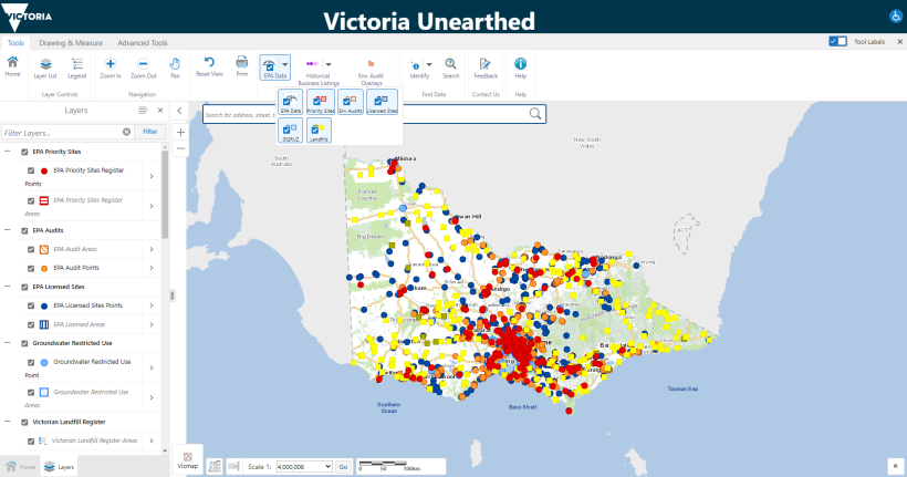
Note: This image shows a VU map with all EPA layers turned on.
Source: DEECA.
VU's datasets
VU has 7 datasets, which Figure 2 lists.
These datasets have information on potentially contaminated sites across Victoria.
VU also has other Victorian Government information about planning and property. For example, planning zones and overlays.
Figure 2: VU’s datasets
| Dataset | Source | Context and description |
|---|---|---|
|
Priority Sites Register |
EPA |
Sites where EPA has issued a notice to manage contamination. Typically, these are sites where land or groundwater contamination presents an unacceptable risk to human health or to the environment. |
|
EPA Licenced Sites |
EPA |
Sites licensed by EPA based on activities that can pose a high risk to the environment and human health. Licence conditions help to control these risks. |
|
EPA Environmental Audits |
EPA |
Sites with completed environmental audits. A complete environmental audit does not mean a site is contaminated. |
|
Groundwater Quality Restricted Use Zone |
EPA |
Audited sites with residual groundwater contamination. This is often due to past industrial activity. |
|
Victorian Landfill Register |
EPA |
Landfill sites, which can have waste from houses, construction and other industries, including asbestos. Landfill sites need to be carefully managed, even when they are closed. For this reason the register contains locations of current and historical landfills. |
|
Historical Business Listings |
DEECA |
Sites that have been historically used for business activities, which may increase their risk of contamination. This data was sourced from the Sands and McDougall business directories (old phone books), which the State Library Victoria holds |
|
Environmental Audit Overlays |
Department of Transport and Planning
|
Contaminated or potentially contaminated sites. If a site has an environmental audit overlay it needs to be audited before it can be used for a sensitive purpose, such as houses, a school or a kindergarten. |
Source: VAGO, based on VU's website.
Figure 3 shows an example of VU's Historical Business Listings dataset.
Figure 3: An example of VU's Historical Business Listings dataset
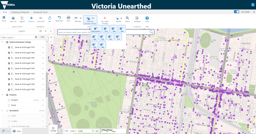
Source: DEECA.
VU users
VU is a public database. But DEECA and EPA told us most VU users are professionals who work for organisations like EPA and local governments or as environmental consultants and auditors.
Independent inquiry into EPA
What the Inquiry looked at
In 2015, the Minister for Environment, Climate Change and Water appointed a ministerial advisory committee to do the Inquiry. It began that same year.
The Inquiry considered how to protect public health and the environment for future generations while ensuring sustainability and job growth. It assessed EPA's role, powers, governance funding and tools.
The committee finished the Inquiry in 2016. The government responded to it in 2017.
The Inquiry’s recommendation
The Inquiry recommended the government 'develop a comprehensive statewide database of sites that pose a high risk to the community because of their past use'.
This is because:
|
The Inquiry found … |
A central database would address this by… |
|---|---|
|
existing data on sites’ past uses and environmental audits was informal and not publicly accessible. |
|
|
responsible agencies did not always target their regulatory actions or monitor compliance. |
helping agencies manage or clean up contaminated and potentially contaminated sites. |
|
Victoria’s planning system required developers and councils to do ‘unnecessary’ audits, which led to extra costs and time delays. |
helping them focus audits on sites that are identified as contaminated or potentially contaminated. |
The government's response to the Inquiry
In response to the Inquiry, the government committed to creating a statewide database to publicly share:
- existing data on contaminated land from different government agencies
- information about potentially contaminated sites’ past uses
- information about sites that have been environmentally audited and any actions to address issues
- guidance materials on how to interpret the information.
VU's governance
In August 2017 DEECA established a project steering group to oversee the VU project and assess if it met the Inquiry's recommendation.
Executives and management from both DEECA and EPA were in the group.
DEECA led the VU project in partnership with EPA.
The Victorian Government’s data quality requirements
VU's data quality requirements
The Standard applies to all departments and Victoria Police. The Data Quality Guideline Information Management Framework (the Guideline) gives more information about the Standard.
The Guideline gives departments advice on how to assess, maintain and improve the quality of their data.
It outlines 7 dimensions to measure data quality, which Figure 4 shows.
Figure 4: Data quality dimensions

Source: VAGO, based on the Guideline.
EPA does not need to follow the Standard because it is not a department. But DEECA must make sure third-party data providers, including EPA, meet equivalent standards.
DEECA and EPA have a memorandum of understanding and data framework for VU. These documents outline the data quality expectations for each agency. These expectations align with the Standard's requirements.
2. Fulfilling VU’s intended purpose
VU fulfils the Inquiry's recommendation to create a statewide database of potentially contaminated sites. But DEECA has not evaluated VU to make sure it reaches its full potential as a reliable and user-friendly source of information.
VU has useful data but it is not presented as a comprehensive database
VU data
In line with the Inquiry's recommendation, VU combines data from different government agencies on potentially contaminated sites.
VU's 7 datasets inform users about:
- EPA’s enforcement activities, licences and audits, which indicate what sites might be contaminated
- what sites are at risk of contamination due to how they were used in the past.
VU is the first Victorian platform to combine these datasets and present them on a map. This makes it easier for users to:
- navigate complex data
- determine if a site is potentially contaminated.
DEECA's disclaimer about VU
VU’s website has a disclaimer that describes its data as unreliable and potentially inaccurate. DEECA based the disclaimer on legal advice it got in 2018.
This legally protects the government and VU users. But it tells users that VU may not be a reliable database of potentially contaminated sites.
|
The disclaimer says … |
This suggests to users that … |
|---|---|
|
data in VU is ‘limited, incomplete and may be inaccurate’. |
they cannot rely on VU to make informed decisions. |
|
the government does not ‘check if VU’s information is accurate’. |
|
|
VU is a ‘starting point for enquiries’ and users should make their own decisions about information by visiting linked sources. |
they need to use other sources to check information. The ‘ad hoc’ and ‘piecemeal’ nature of accessing contaminated land data was one of the issues the Inquiry's recommendation wanted to address. |
DEECA and EPA understood users’ needs when designing VU but have not evaluated VU
Designing VU
DEECA and EPA designed VU based on a comprehensive understanding of potential users’ needs.
Two years before they launched VU, DEECA and EPA:
- got external consultants to design a user experience testing program
- ran workshops and focus groups with potential users, including experts, professionals and members of the community
- assessed if available information on contaminated land met users’ needs and expectations
- got technical and professional users to test a prototype of the platform to identify areas for improvement.
This work helped DEECA and EPA make sure VU met users’ needs when they launched it.
Evaluating VU
DEECA gives individual VU users the opportunity to:
- submit feedback about issues
- do an online survey.
DEECA and EPA have fixed data errors and improved data quality through this feedback.
But DEECA has not evaluated VU since it launched in early 2019. This means DEECA is missing the opportunity to understand if VU is fit for purpose.
DEECA initially outlined 2 phases for the VU project:
- phase 1: create and launch VU
- phase 2: review VU to understand if it is fit for purpose and easy to use.
To date, DEECA has not done the phase 2 review.
End-of-project governance
In its final meeting in October 2019 VU’s project steering group noted that DEECA needed to do a ‘more extensive’ evaluation to assess if VU is:
- informing the community about potential contamination risks
- helping individuals, the government and councils make informed decisions about developing sites.
To date, DEECA has not done this evaluation.
Despite this, the project steering group marked the VU project as complete at the October 2019 meeting because it fulfilled the government's commitment to provide a publicly accessible database.
Following the meeting, DEECA:
- moved VU to business as usual, which involves maintaining VU but not improving it
- re-prioritised VU funding for other critical reform projects.
As a result, the VU team did not have the funding or resources to complete the reviews and evaluations they had planned.
Future plans to evaluate and improve VU
DEECA acknowledges it needs to evaluate VU. It plans to improve it in 2023–24.
It told us it is conducting a broader review of contaminated land in Victoria. This will consider proposed improvements to VU.
Not all VU datasets are complete and up to date
Changes to data management system
DEECA and EPA have been slow to update EPA's datasets to reflect the new Environment Protection Act 2017.
This is largely because EPA and DEECA started updating their data management systems in 2021. The 2 systems could not easily send and receive data to upload to VU.
|
As a result ... |
This ... |
|---|---|
|
VU does not have data on environmental audits and new licensed and priority sites after July 2021. |
means not all VU data is up to date. |
|
VU's website redirects users to EPA's website to access new data, which is in a list. |
means users cannot access information in one place, which the Inquiry recommended. |
|
VU does not have up-to-date spatial data for all its datasets. |
may reduce VU’s scope and functionality. |
Addressing the risk of out of date data
At the project steering group's final meeting in October 2019, EPA said there was a risk that VU’s data would be out of date when the new Environment Protection Act 2017 came in.
DEECA and EPA did not address this risk until 2022 because:
- EPA had re-prioritised its resources to other projects that came out of the Inquiry, which involved higher-risk operational or regulatory activities
- DEECA and EPA moved VU to business as usual and closed the steering group in October 2019, which reduced their communication about VU
- EPA did not formally communicate with DEECA until April 2021 about its new data management system not being able to send data for DEECA to upload to VU from July 2021.
Plans to address data quality issues
In 2022 DEECA gave EPA extra funding to update EPA's data systems to:
- address data quality issues
- be able to supply up-to-date spatial data.
EPA tested its system and DEECA's data management system. It did technical work to make sure its system could directly send DEECA updated data.
EPA also made its datasets more consistent across its old and new platforms. This is because its old platform aligned with the former Environment Protection Act 1970.
EPA planned to complete this work by 30 June 2022. But it completed it in October 2022. The delay was partly because DEECA's new data management system was not ready for testing.
3. Complying with the government’s data quality requirements
DEECA and EPA comply with the Standard's minimum requirements. But they need to share more comprehensive information about VU’s data quality with its users.
DEECA and EPA comply with the Standard's minimum requirements
The Standard's requirements
DEECA and EPA meet the Standard's minimum requirements to:
- assess critical datasets against the data quality dimensions to make sure they are fit for purpose
- have a data quality statement that outlines known data quality issues
- have a data quality management plan to address data quality issues
- have accountable officers to manage data quality.
Additionally, DEECA made its own data framework in 2018 before the Standard came out later that year. It did this to outline its quality expectations for the agencies who supply VU’s data.
This shows DEECA’s commitment to data quality. However, DEECA does not fully comply with this framework yet because of the evaluation issues we discuss in Chapter 2.
Data quality statements
The Guideline tells departments:
- what they should include in a data quality statement
- how they should use the statement to communicate with users about data quality.
As Figure 5 shows, DEECA's and EPA's data quality statements only partially comply with the Guideline because they are not available to VU users.
VU’s website has information about each dataset. But it is not as detailed as their data quality statements.
As a result, there is a risk users may find it difficult to make informed decisions about using VU’s data.
Figure 5: Our assessment of VU's data quality statements against the Guideline
| Criteria | Compliance | Our assessment of issues |
|---|---|---|
|
Summarises known characteristics that may affect a data asset's quality |
Yes |
NA |
|
Highlights a data asset's strengths and weaknesses to help users determine if it is fit for their intended purpose |
Yes |
NA |
|
Forms part of a disclaimer around using a data asset |
Partial |
VU's disclaimer does not reflect the detailed information in its data quality statements. For example, the disclaimer says data in VU may be inaccurate. But EPA's data quality statement for Groundwater Quality Restricted Use Zone says the dataset has a very high level of accuracy. |
|
Is discoverable to users to help them interpret and use data |
Partial |
DEECA and EPA have not published their data quality statements online for users to access. There is other information about VU's data quality at Data.Vic, which is a public portal for government data. But DEECA and EPA do not give users clear instructions on how to access this. |
|
Appoints data custodians to ensure statements are complete and up to date |
Yes |
DEECA is the data custodian for VU. It makes sure it and EPA produce data quality statements, or equivalent information, for VU’s datasets. |
|
Records the status of statements in the department’s information asset register |
Yes |
NA |
|
Defines a data asset's quality within the department's information asset register or data management system |
Yes |
NA |
Source: VAGO, based on the Guideline.
Data quality management plans
The Guideline says a data quality management plan should:
- assess a dataset against the data quality dimensions
- include plans to address known issues.
Under the Standard, DEECA is responsible for making sure each VU dataset has a data quality management plan because it 'owns' the platform.
Five out of VU’s 7 datasets have a data quality management plan.
DEECA does not have a plan for its Historical Business Listings dataset. But it told us it understands the dataset’s limitations.
EPA did not have formal data quality management plans until 2022. But it had equivalent documentation that showed a good understanding of its datasets’ quality and limitations.
Data governance
DEECA and EPA meet the Standard's requirement to have an accountable custodian for each VU dataset.
However, as we discuss in Chapter 2, VU's project governance ended in October 2019. This limited EPA and DEECA’s communication about data quality risks.
Since March 2022 DEECA has funded EPA to:
- complete a range of data supply activities
- improve the compatibility of EPA's and DEECA's data management systems.
As a result, DEECA and EPA have improved how they oversee and manage VU’s data quality.
Appendix A. Submissions and comments
Download a PDF copy of Appendix A. Submissions and comments.

Appendix B. Abbreviations, acronyms and glossary
Download a PDF copy of Appendix B. Abbreviations, acronyms and glossary.
Appendix C. Review scope and method
Download a PDF copy of Appendix C. Review scope and method.